


Sainte-Sabine *

olaze
User

Length
11.1 km

Max alt
10 m

Uphill gradient
56 m
Km-Effort
11.9 km

Min alt
1 m

Downhill gradient
56 m
Boucle
Yes
Creation date :
2014-12-10 00:00:00.0
Updated on :
2014-12-10 00:00:00.0
2h28
Difficulty : Easy

FREE GPS app for hiking
 SityTrail
IGN / Geographical institutes
SityTrail Plus
The world is yours!
About
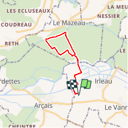
Trail Walking of 11.1 km to be discovered at New Aquitaine, Deux-Sèvres, Le Vanneau-Irleau. This trail is proposed by olaze.
Description
Promenade départ et retour de Sainte-Sabine, à travers le marais, passerelle de village de la Sèvre,camping du Mazeau.11,1 Kms.
13/12//11
Positioning
Country:
France
Region :
New Aquitaine
Department/Province :
Deux-Sèvres
Municipality :
Le Vanneau-Irleau
Location:
Unknown
Start:(Dec)
Start:(UTM)
679727 ; 5130139 (30T) N.
Comments